Lighthouse Country Regional Trail is roughly a 5 km trail south of the Nile Creek Trail. This is a very straight & easy walk, hike, bike explore outing. This trail is built to allow wheelchairs, so it is of a different character to the other trails I have so far talked about.
The trail is wide & smooth with a gravel road allowing for the accessibility of wheelchairs.
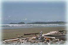
 |
| Lighthouse Country Regional Trail |
The trail is part of the Lighthouse Country Trail talked about in a previous post. Both these trails are joined by a bridge that crosses over Nile Creek. Once I have talked about each individual trail, I will then talk about how you can walk, hike, bike (on most trails) & explore the trails from Horne Lake Rd
to Bowser as they all join up to make one long
walk, hike, bike, explore adventure.
Check out the site below to find out more information on the Lighthouse Country Regional Trail.
There are two places to access Lighthouse Country Regional Trail. If you are coming from Nanaimo down Horne Lake Rd you
turn left towards Qualicum Bay. As you drive through the village, please watch your speed, you will see the Sandbar Cafe on your right & opposite the cafe is Lions Way. It is right on a curve so go slow as it is easy to miss. Turn left up Lions Way & then turn right onto Lioness Blvd. Follow the road to the parking area at the end of the road & you will see the trail on your right. If coming from Courtney side take the Cook Creek exit & turn right into Bowser. Head straight through the village, please watch your speed, until you come to Charlton Dr. This is the same road as if going to the Nile Creek Trail, but you will turn left onto Linx Rd which is half way down Charlton Dr. Just follow Linx to the end & park either in the cul-d-sac or over the tracks. You will see the trail on your left.
What I enjoy doing is starting from Linx Rd,
walk, hike , bike, & explore Lighthouse Country Regional Trail & then at the end of the trail on Qualicum Bay side, turn right onto another trail. Now you are back onto a natural, rugged trail which is not wheelchair accessible, but is great for walking & hiking. Unless you are an experienced mountain biker, I would hesitate to bike as there are a couple of areas that are tricky. As you walk, hike, (bike), explore through
the first part of this trail, you will see trails branching off, as mentioned above I will talk about how to join these trails up. So for the time being stay on the main trail & follow it down over a creek & up a fairly steep hill. The trail becomes wider & eventually you reach a dirt road that is a driveway. Turn right & walk across the road a little & you will see the trail continue which will come out to a dirt road. If you can't find the trail, don't worry just continue down the driveway & you will come to the dirt road. (Just make sure you have turned right onto the driveway!). Upon reaching the dirt road, turn left & walk across the road, look for a blue jerry can hanging in the tree indicating where the trail carries on. If you found the trail across the driveway, when you reach the dirt road, cross over, you should see the blue jerry can opposite.
After a bit of time of walking, hiking, biking & exploring you will come out to a pine forest where there are numerous tracks for dirt biking etc. This is where it gets a little confusing, just keep walking, hiking, biking in a straight line as best as you can, watch out for ribbons in the trees as these are markers for the trail; after a bit you will see the trail ahead of you.
 |
| Keep heading straight |
Once on this part of the trail, it becomes somewhat steep & narrow, so if on a bike be cautious.
 |
| Steep climb down. |
Once you have reached the bottom of the walk, hike, (bike) down the hill there is a bridge that takes you to the Big Qualicum River Hatchery if you are interested in exploring that. From here you can either head back the way you came or before crossing over the bridge the trail continues around & back up the bank running next to the train bridge. This is where it is tricky with a bike as you have to haul it up. There is a rope in-bedded into the ground to help you climb up, but it is slippery & if it has been raining, it will be muddy.
Upon reaching the top you will see trails off to your left, I haven`t explored them yet, but my guess is they are the dirt biking tracks.
Just keep heading straight, you will see some buildings & railway tracks ahead of you.
 |
| Steep climb with rope |
Once you reach these structures turn left & walk, hike (bike) & explore the dirt road until you come to the blue jerry cans. There is one on either side of the road. Turn right & follow the trail that will take you across the driveway and down the trail again. You are now back tracking & will eventually come back down to the Lighthouse Country Regional Trail. This is approximately a 1 1/2 - 2 hour walk.
Ready for an ice-cream, well the Cone Zone in Qualicum Bay is open. They have 32 flavours to choose from!! Just turn right when you come out onto the West Island Highway & you will find it on the right just past Henry's Kitchen.
NOTE: Most of these trails have a coloured ribbon tied to a tree which indicates a trail, they are generally pink. Don`t count on these ribbons though, always be cautious, don`t attempt things you are uncomfortable about, & remember to be responsible for yourself & others in your party. Don`t forget the bears are out, so take precautions as mentioned in previous posts & don`t forget your water bottle & cell phone.
PLEASE be responsible for your dog(s), take doggy bags out with you if using, otherwise push doggy poop into the bush off the trails. THANKS.
Please let me know if links are not working, or pictures are not showing.
HAPPY WALKING, HIKING, BIKING & EXPLORING

-----------------------------------------