Monday, April 29, 2013


JUST A TASTE OF THINGS TO SEE & DO ON VANCOUVER ISLAND, BC

www.google.ca

Carolyn Walton has spent the last 32 years as a travel writer & photographer. She has travelled all over North America and the world taking pictures & writing about her experiences.  Through all her travels & ventures Vancouver Island is her favourite destination. TAKE A LOOK AT HER BLOG: & discover stories & adventures written by Carolyn about Vancouver Island.

Take a look at some of the activities to be enjoyed on Vancouver Island.

Red sky @ night, Sailors delight
Hanging out on the beach
Surfing West Coast

Killer Whale on the hunt.


Mt. Washington


All above images are taken from www.google.ca

----------------------------------------------------------------------------

Sunday, April 28, 2013


LOWER NILE CREEK TRAIL


A forest is the ultimate sustainable cooperative community.

http://vancouverislandbigtrees.blogspot.ca


This is one of my favourite trails to walk, hike, bike & explore as it runs along Nile Creek for most of the way. As you walk, hike, bike along the trail you hear the sounds of the creek rippling & babbling along or roaring through at a wild swiftness depending on the time of year as it journeys down it's path to the ocean.


A taste of BC's rainforests
You are surrounded by old Douglas fir trees that are standing over you protecting you from the elements which are home to different kinds of fungi growing on them.  
Everywhere you look you see different shades of green from the different trees & different kinds of moss growing on the ground & on the trees. 
"It is not so much for it's beauty that the forest makes a claim upon men's hearts, as for that subtle something, that quality of air, that emanation from old trees, that so wonderfully changes & renews a weary spirit". Robert Louis Stevenson

The lower Nile Creek trail is roughly 1 1/2 - 2 hours long depending on your speed. It is a fairly easy walk, hike, bike trail & a common biking trail without too many challenges along the way. (Non of these trails in Lighthouse Country are suitable for young children to bike, they are for people with some experience of biking in forests & mountains).
Alternate route
The trail runs along Nile Creek for the most part; about half way along it branches off so there is a higher route & a lower route that make a loop. The recommendation is for bikers to use the higher route, but there is nothing written in stone about this. The lower route is a little muddier with a few areas that create a bit of a challenge, such as a trail built out of round logs that you would have to push your bike over. The higher trail gives you a bit more of a work out as you are climbing, but it is not what I would class as an advanced trail. Non of the trails in Lighthouse Country I believe are too challenging & are suitable for all ages so long as you are fairly fit & able to walk up hills. There is an area where you cross over the creek by a log that has a rope handrail, so walkers, hikers, bikers be cautious as you cross over.

To find NIle Creek trail you take the same route to Bowser as mentioned in my previous post regarding The Lighthouse Country Trail. If coming from Nanaimo turn right onto exit 75 (Horne Lake exit) & head towards the ocean & if coming from Courtenay side turn left onto exit 87 (Cook Creek exit), again heading towards the ocean. When you get to the West island Highway (19A), folk from Nanaimo will turn left & head north, folk from Courtenay side will turn right onto 19A & head south. Nanaimo folk will pass through Qualicum Bay & Courtenay folk will pass through Bowser. The road you are looking for is Charlton Dr which is approximately half way between both villages. Courtney folk will cross over Nile Creek bridge & the next road on your right is Charlton Dr. For Nanaimo folk, when you see the speed limit flashing overhand Charlton Dr will be coming up on your left side.
Follow Charlton Dr right to the very end & park. There is a gate in front of you, if it is closed just follow the path on your right. You will be on a dirt road for a while & will pass the Nile Creek Hatchery on your right. Just walk, hike, bike until you come to a trail on your left side & away you go. 


Nile Creek Trail

CAUTION:  Don't forget that this is bear country, the bears are out, so wear a bear bell, take a large heavy stick & it is a good idea to have bear spray. Remember, you are in a rainforest & when the winds are high there is always a danger of old rotten trees falling, so keep you ears open, take care of yourself & others in your party; you are responsible for yourselves out there. Make sure you have water & a cell phone. 
To round off your adventure in Lighthouse Country, when you have finished walking, hiking, biking & exploring you can either turn left on highway 19A & head into Bowser to the Bean Counter for a coffee or tea & browse around the unique shops in the strip mall or go treasure hunting at Things & Stuff Old & New, the local 2nd hand-store  (Never know what you will find in there). Otherwise you can turn right on highway 19A & head south to Qualicum Bay. Here you have a choice for food & drink. There is the local pub, Crown & Anchor where lunch & dinners are served, or across the street is the Sandbar Cafe where the food is great & there is a very interesting art gallery inside with beautiful paintings from local artists. If you are in town on Fridays, Sandbar has local musicians that congregate & jam in the evening, so if you are a musician, bring along your instrument(s) & voice and join in; meet some local folk. Otherwise just down the road is a new cafe called The Alpaca cafe & gift shop. They have an Alpaca farm behind, so many of their gifts are made from Alpaca wool, ooooh, sooo soft. 
Any time soon the local ice cream shop, The Cone Zone with 32 flavours of ice cream will be opening up, & right next door to The Cone Zone is Henry's Kitchen where they serve Chinese food. You won't starve in Lighthouse Country!


HAPPY WALKING, HIKING, BIKING & EXPLORING


www.google.ca
-----------------------------------------------


Thursday, April 25, 2013

APRIL 27th, 2013 A FREE FOOD REVOLUTION STARTS

"The body is like a piano, & happiness is like music. It is needful to have the instrument in good order". Henry Ward Beecher


www.google.ca
Did you know that Monsanto spends 10's of millions of dollars to keep us in the dark about what we are eating. For example, genetically modified organisms (GMO's) are unlabelled, inadequately tested, & most North Americans are eating them every day in corn, soy, canola oil and more.

Just to name a couple of disasters linked to the spread of GMO's such as: food allergies (not too surprising), & the steady collapse of bee colonies.
Monsanto & their cohorts want us all to stay in the dark, but the free Food Revolution Summit is one way we can take action to become educated & learn about the dangers regarding genetically engineered, pesticide-contaminated, highly processed pseudo-foods, which they want us to believe are considered normal foods!

As a re-cap of what you will learn from the Free Food Revolution Summit, here is an example:
  • How to prevent companies like Monsanto from destroying your health and the health of the planet
  • What should you really be eating for the best health, energy, and mental clarity?
  • How to prevent and even reverse heart disease without drugs, surgery, or excessive exercise
  • What's the real truth about soy? Is it a healthy food or something to be avoided?
  • How to determine if you're allergic to certain foods
  • Are organic foods worth the extra cost?
  • What can you realistically do to make a difference in the health and sustainability of the planet?... and many other topics
If you would like to get started with taking control of what you feed your body & mind, not to mention saving money, JUST CLICK HERE & sign up for the free Food Revolution Summit so that together we can fight this pollution with our knives & forks to bring a healthier, more energetic & a brighter world for ourselves, our children & future generations.   
www.google.ca
   
There is another option if you feel you don't have the time to participate in the Food Revolution Summit or if you would like extra support in getting help; just check out @ emeals as they will help you find solutions on-line for a variety of meal plans suitable for a range of diets such as clean eating, paleo, low fat, low carb, natural & organic, portion control, gluten free, classic & vegetarian diets. JUST CLICK HERE to see what @ emeals "Meal Planning Made Simple" can help you with. 


www.google.ca
"WITHOUT HEALTH, LIFE IS NOT LIFE; IT IS ONLY A STATE OF LANGUOR & SUFFERING"  Francis Bacon  
------------------------------------------------


Tuesday, April 23, 2013


Walking, Hiking, Biking & Exploring Trails IBowser, BC

www.google.ca
"WALKING IS THE NATURAL RECREATION FOR A MAN WHO DESIRES NOT ABSOLUTELY TO SUPPRESS HIS INTELLECT, BUT TO TURN IT OUT TO PLAY FOR A SEASON". 
Leslie Stephen

The trail system in Lighthouse Country link up fairly nicely so that you can walk, hike, bike (some of the trails) & explore the more common trails found in the area which start from Dunsmuir Rd, just off Horne Lake Rd which comes down towards the coast off the Inland Highway, exit 75.

Some of the trails are named and some are not, so I will do my best to describe the routes & conditions of these trails.

Coming in from exit 75 (Nanaimo side) you will follow the road down towards the ocean & turn left onto West Island Highway (19A), drive through Qualicum Bay to Bowser (approximate 5 minute drive). Just before you reach Bowser Village on the left is Macoll Road, you want to turn up there, follow the road up & across the train tracks where you can park.
If you are coming from Courtenay area, take exit 87, Cook Creek exit. Once you hit the West Island Highway, turn right and with an approximate 5 minute drive you will come to Bowser. Drive through Bowser Village & the first road on your right is Macoll Rd.

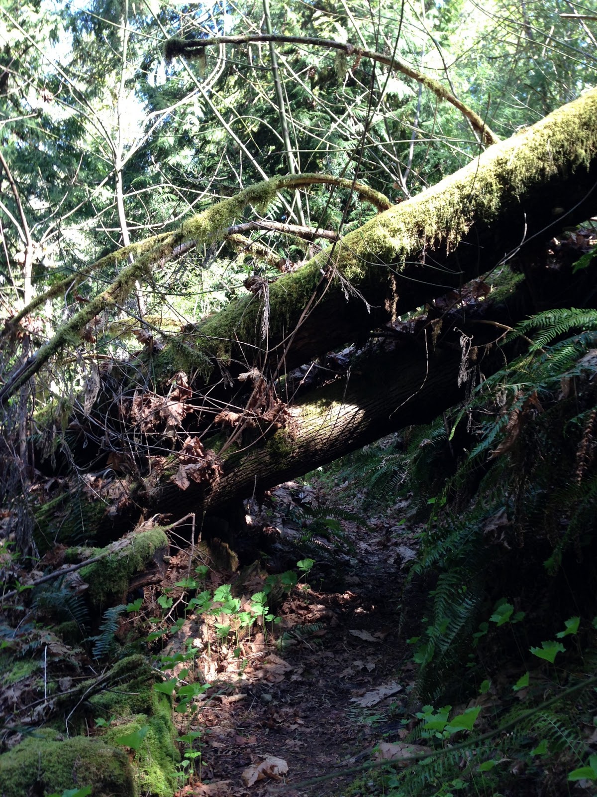
There are 2 trails here that link up, so that makes it a nice loop creating a very pleasant & fairly easy walk, hike, bike!!, explore experience lasting roughly an hour depending on how fast you walk, hike, bike & explore. If you park on the left side of the parking area walk across the gravel road and head down the no-named trail in front of you. You will see a couple of trails branching off on your left from this main trail & these will take you up above the creek & are easy enough trails to walk, hike, bike & explore. Be aware that the trail you start off on goes down to the creek and then runs along the creek; this trail is not such an easy trail for biking due to fallen trees, other obstructions & the fact that you have to carry your bike up the bank to connect with the upper main trail.  
Obstruction, a tree tunnel

Upper trail


Upper trail


steep & bumpy decline
   If you are an experienced mountain biker that is accustomed to lugging your bike down banks & over logs etc., you probably won't find this trail too challenging. For inexperienced mountain bikers and children with bikes, I would not advise biking this lower trail. It is probably wise to walk the trail first & then make a judgement call on whether to go back & bike it.
Log obstruction
Gone too far
While walking, hiking, biking (!!) & exploring the lower trail, if you come to the creek with a log path going across the creek, you have gone too far. Just turn around & take a few steps back & you will see the trail heading up the bank. You need to follow that & that will bring you up to the upper trail which will take you out. 


Once you have walked, hiked, biked & explored around this area you will come out onto the gravel road again, turn left on the road & head back down until you come to the Wildwood Community Park on your right. (Approximately 4-5 mins walk). This is a big field where kids can let loose to ride their bikes, run around, you can have a picnic, play Frisbee &/or throw sticks & balls for your dog etc.

When walking into Wildwood Community Park, on your left is a metal gate with a trail running on the left side of the gate. You want to take this trail which is called Alice's Trail. The trail goes either left or right, I suggest you take the right side going up the hill and follow it around. Be aware that it branches again so you want to follow it around on the left side otherwise you will end up crossing a creek and back to the park. (There is a sign for Alice's Trail).
It is not a very long trail, but very pretty & easy walking, hiking & biking & it won't be long before you come to the Lighthouse Country Trail. Once you are walking, hiking, biking & exploring Lighthouse Country Trail, which again is a loop, keep to the right of the trail as there are trails branching off which are just short cuts to the other side of this trail.

Knobbly tree roots on trail
Muddy & knobbly trail
You need to keep your eyes on this trail as there are a fair amount of tree roots on the path, and when it is raining this is a wet & muddy area, so have good hiking shoes & rain gear.  
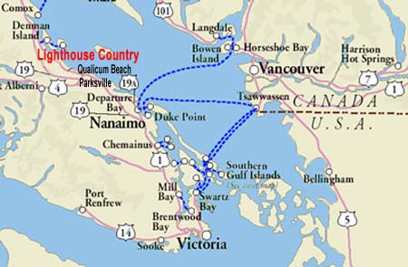
Map of Lighthouse Country Trail
    It is a fairly popular biking trail, but as mentioned, keep your eyes open for tree roots etc. on the trail. This trail will go all the way around and back to where you have parked your vehicle. (See map above).   
CAUTION: This is bear country, so be aware of that. I walk with a strong sturdy stick & wear a bear bell attached to my shoe lace, & my dog wears one on her collar. This is so we are warning the bears that we are around. The bear bells can be purchased in Bowser at the hard-ware shop or at the garden shop. The other option is to buy bear spray. 
Please remember that you are responsible for your-selves & others in your party & don't forget your water bottle & a cell phone. Please be responsible about your dog poo & keep your dog on a leash if it is unpredictable. My other bit of advice is, if the winds are strong  I stay out of the Lighthouse Country Trail as there are some old trees that could fall. It gets a little creaky in there!!
Douglas Fir Ecosystem                                                           
After you have had fun walking, hiking, biking & exploring these trails why not turn left when you come down Macoll Road onto West Island Highway & head into Bowser Village for a cup of coffee or tea. You will find the Bean Counter which serves all types of fancy coffees & teas along with great sandwiches made from the best multi-grain bread I've ever had. Or maybe you may fancy a soup or salad or the daily specials. It is hard to be disappointed with a visit to the Bean Counter. 
Bowser's famous Bean Counter Cafe

There are some interesting and unique shops in the same strip mall as the Bean Counter which you can take a brows through. Lighthouse Country has some incredible artists & a lot of their work is found in the Salish Sea Market just up from the Bean Counter. Here you can find a variety of art work, all of it being one of a kind.
HAPPY WALKING, HIKING, BIKING & EXPLORING

www.google.ca
-----------------------------------------------


Thursday, April 18, 2013

Allowing ourselves the ability to walk, hike, bike & explore


www.google.ca
"TO KEEP THE BODY IN GOOD HEALTH IS A DUTY, OTHERWISE WE SHALL NOT BE ABLE TO KEEP OUR MIND STRONG & CLEAR".  Buddha

Food Revolution Summit - It's Free

Walking, hiking, biking & exploring are physical activities that require our body & mind to be strong & healthy in order to perform & enjoy life. Our diet plays a major role in fuelling our body with the necessary energy to give us the strength to walk, hike, bike & explore.

In the latest newsletter I subscribe to from Steve Pavlina, a personal development insight guru, he talks about  healthy eating and how it not only benefits your physical body, but also your mind. 
www.google.ca
How many of us as kids were bribed by food as a means for good behaviour?
"When I was a kid and my mom would take my siblings and me to the local shopping mall, she'd bribe us with an offer of an ice cream cone from Baskin-Robbins if we'd behave ourselves. So if we acted like monkeys in the stores, we wouldn't get any ice cream on the way back to the car. Most of the time, sometimes with a large amount of begging and pleading, we were able to get our cones".
 Pavline, S; (2013, April 17). Steve Pavlina.Com Personal Development Insights Newsletter.

www.google.ca
www.google.ca


I wonder how many of us grew up unaware of the damage done to ourselves through the influence & habits of eating refined foods full of fat, grease, sugars & too much salt. It has only been in the last 10 years or so that we have been informed through social media that we as a society are not very healthy due to these eating habits. 

I would like to share with you a Free Food Revolution Summit that you can subscribe to on-line  

"Here are some of the topics covered by the summit:
  • How to prevent companies like Monsanto from destroying your health and the health of the planet
  • What should you really be eating for the best health, energy, and mental clarity?
  • How to prevent and even reverse heart disease without drugs, surgery, or excessive exercise
  • What's the real truth about soy? Is it a healthy food or something to be avoided?
  • How to determine if you're allergic to certain foods
  • Are organic foods worth the extra cost?
  • What can you realistically do to make a difference in the health and sustainability of the planet?
  • ... and many other topics
If you'd like to get started, CLICK HERE: Food Revolution Summit to sign up now. Again, it's totally free. There's a free bonus when you sign up too.
Please help spread the word about this summit if you can. The more people who invest in our long-term health and sustainability, the better". 
Pavline, S; (2013, April 17). Steve Pavlina.Com Personal Development Insights Newsletter.

Another option to help you find solutions on-line for a variety of meal plans suitable for a range of diets such as clean eating, paleo, low fat, low carb, natural & organic, portion control, gluten free, classic & vegetarian is through @ emeals meal planning made simple. JUST CLICK HERE 

It takes one step at @ a time to get strong & healthy. Don't forget, what we feed our body fuels our bodies & minds and that determines whether we have the strength to walk, hike, bike, explore & enjoy life.

"THE GROUNDWORK FOR ALL HAPPINESS IS HEALTH".
James Leigh Hunt


www.google.ca

----------------------------------------------------------------------------------------------------

Tuesday, April 16, 2013

Being Responsible for oneself & others.


"THE FIRST CHOICE IS ALWAYS YOURS, TAKE RESPONSIBILITY FOR YOUR ACTIONS" 
Unknown


Being Responsible For Oneself & Others In Your Care While Walking, Hiking, Biking & Exploring.


It’s turning out to be interesting & challenging in regards to finding & uploading a map of the trails that are available in Lighthouse County for walking, hiking, biking & exploring.  Due to conversations I have had thus far, the reason given is that it is not advisable to have maps available for the public for fear of legal repercussions in the event that someone gets hurt or worse.

If this is the reason for not having public knowledge of these trails for walking, hiking, biking & exploring, how sad is that?  How sad to have reached a place in society where fear of being sued due to accidents occurring because of actions, decisions & choices made by other people hampers, in this case the ability to walk, hike, bike & explore Lighthouse Countries beautiful trails. It seems that we are not prepared to take full responsibility of ourselves & our families any more.  Instead the trend it seems is to blame other people for accidents that happen due to actions, decisions & choices made by the person(s) suing.  

I don’t know about you, but I feel like my freedom is jeopardised due to so many rules & regulations that are in place as a means of protection from being sued. I am a responsible adult that takes into consideration the dangers in situations, and can make a decision on whether something is too dangerous for me or others under my care. Being that adult, I also understand that if something was to happen due to my decision, then I am responsible for that & no one else. Having that power helps make me a responsible adult.  
So I guess we have no one to blame but ourselves if this is the reason I cannot post maps on my blog to share with you on trails for walking, hiking, biking & exploring Lighthouse Country.

The trails are well built, but the idea behind them is to have the experience of being out in the natural environment, imagining what it was like before there were roads and pavement & you had to walk everywhere on natural ground & overcome unexpected challenges along the way. So that means that construction for stairs and bridges etc. are kept in line with the natural environment as much as possible. Therefore, you will come across situations that require you to be sensible, careful & assess the situation to see if it & all in your party are comfortable & capable of proceeding. There's no doubt that there are areas that require caution, you have to be aware of your surroundings and watch where you place your feet. As mentioned in my previous post, you will come across large tree trunks that act as bridges over creeks, some have a rope handrail & some don't, it's easy to slip if you are not taking your time & being careful. Tree roots act as steps, so that makes it easy to trip, but walking up stairs can also cause one to trip if not being aware. Trails can be slippery, especially in the fall & winter after all the leaves have fallen & trails will be muddy when the rains are falling. If you are biking any of these trails, you must be prepared to carry your bike over certain terrain & be aware that not all the trails are appropriate for biking. Having suitable footwear with good support & tread is important. Having rain gear is a good idea as this is a rainforest. Always carry a water bottle and a cell phone in case of an emergency.
www.google.ca
We would love for you to come and walk, hike, bike & explore these trails in our little corner of Vancouver Island. Please feel free to contact me through my blog for any information you require on the trails.  Regardless of whether I am successful in uploading a map of the trails in Lighthouse Country or not, please be aware that you are responsible for yourself & everyone in your care.


www.google.ca
"GOD HAS ENTRUSTED ME WITH MYSELF".  Epictetus

Hope to hear from you with any comments or ideas; happy walking, hiking, biking & exploring your world.

HAPPY WALKING, HIKING, BIKING & EXPLORING
www.google.ca
-----------------------------------------------


Saturday, April 13, 2013

My walking, hiking, biking stomping grounds.


www.google.ca
"Climb the mountains & get their good tidings. Nature's peace will flow into you as sunshine flows into trees. The winds will blow their freshness into you, & the storms their energy, while cares will drop off like falling leaves".John Muir

My walking, Hiking, Biking Stomping Grounds.
Lighthouse Country is a little haven situated along the eastern shore of Vancouver Island, British Columbia (Canada).  It is located midway up Island between 2 lighthouses, hence the name, The Sisters Lighthouse off the northern tip of Lasqueti Island & Chrome Lighthouse off the tip of Denman Island, & covers an area of roughly 300 square kilometres. The population is approximately 4-5000 with a mixture of retirees & working folk. It is home to the Pentlatch-speaking First Nations that have an active community in & around Qualicum Bay, a small hamlet in Lighthouse Country. The area is also rich with artists and musicians scattered throughout, and where beautiful artwork can be found.
The area is rural and blessed with such beauty as rainforests, mountains, caves, beaches, lakes, rivers and creeks. It allows for a wonderful play area all year round whether you enjoy walking, hiking, biking, geo-caching, horse-back riding, spelunking (caving), sailing, water-skiing, surfing, fishing, golf, photography, skiing/snowboarding or cross country skiing, you name it, you can find it in Lighthouse Country. 
With the richness of its rainforests, there are beautiful trails to explore which are scattered throughout the area taking you along creeks, rivers and through magical forests. The majority of the trails are intentionally created in keeping with the natural environment & range from approximately 1 – 2 hours in duration and are essentially suitable for walking & hiking with some of the trails being accessible for biking if you have a mountain bike & are prepared to carry your bike at times. The trails are basically level with some hills which may or may not have stairs and some areas where one is climbing up & down banks.


NOTE: It is very important that visitors using these trails do so at their own risk & understand that they are responsible for their own decisions, actions & behaviour. Please use your own common sense & judgement of your own abilities.
These trails as mentioned have been intentionally designed & created to fit into the natural environment. Generally speaking, the trails are built for single file walking. There are tree stumps & roots that one can trip over if not paying attention & bridges that are built across creeks from fallen logs where
some of them have a rope to use as a handrail & some of them don’t; so that requires your own judgement as to whether you feel safe enough to cross over these logs. You are in a forest, so be aware of high winds as trees do fall down. With the popular use of these trails & the constant exposure to the environment, there is a natural progression of wear & tear, so take care when a trail has been washed out, or a tree has fallen over the trail, or the wooden stairs are a little rotten in places & things are slippery from the rain. Don’t forget, this is a rainforest & you should be wearing suitable shoes with good tread & support. Having rain gear, a cell phone & carrying water is advisable.

Walking, hiking, biking around & through Sitka Spruce, Douglas Fir, Western Hemlock and Western Red Cedar trees that have been standing over us for an unimaginable amount of time, are home to squirrels, wood peckers, ravens, eagles, bears & salmon, just to name a few of the creatures that share these forests. It is a perfect place for contemplation rejuvenation, photography and connecting to nature while exercising the  body.
This is a magical experience with the protection of the trees from the heat, rain or snow, allowing you to wander through these forests that dazzle you with all the different colour greens of moss, ferns and native vegetation while listening to the birds chattering and screeching, wood peckers hammering, creeks flowing, crashing or rippling through on their journey to the ocean. While you share this space exploring the area by walking, hiking, biking, these trails can take you further up the creeks & rivers or deeper into the forests, with the beauty of it all enticing you to keep going, to see what's around the next corner, what's over that hill or down that ravine. 
If you are a dog lover and owner, well your mate has found heaven & is free to sniff, run, swim and explore with joy without being restricted by a leash.
NOTE: Please be responsible for your dog. There is nothing worse than coming across a plastic doggy bag that the owner has decided to leave on the side of the trail, or a pile of poop on the trail waiting for someone to step in. If your dog has pooped on the trail or just on the side of the trail, it is better to use a stick & push it off into the bush to decompose naturally rather than pick it up with a doggy bag and then leave the bag out there. Just be aware of pushing the poop right off into the bush. If you do use a doggy bag PLEASE take your bag home with you.
www.google.ca
  If your dog is not very sociable and/or unpredictable, please take responsibility & have it on a leash to avoid any problems. These trails are for us all to enjoy, so please help us keep it this way.

This environment tweaks the imagination with visions of leprechauns, faeries and unicorns. For those of you who have seen the movie Avatar, you now have a visual of British Columbia's (BC) rainforests. Although the movie was not filmed here, it could well have been. There is one trail in Lighthouse Country that has been built through the RDN for multi-purpose use. Take a look at the following link to get more information. http://www.rdn.bc.ca/cms.asp?wpID=2584
This is an easy destination for day trippers living in and around the Nanaimo area, Courtenay or Campbell River. Folk living further away will find this a great corner of Vancouver Island to explore & enjoy the natural beauty, meet local islanders, enjoy a variety of annual festivals & events, buy beautiful unique jewellery, art, pottery & much more, enjoy local seafood & have plain old fun. You will find that Lighthouse Country has a variety of great accommodations ranging from camp-grounds  B & B’s, resorts, funky lodgings & house rentals. I will talk about them another time. In the meantime take a look at the following site to discover a little more about Lighthouse Country.
http://lighthousecountry.ca


HAPPY WALKING, HIKING, BIKING & EXPLORING

-----------------------------------------------